Webster

The Constitution was made to guard the people against the dangers of good intentions." --American Statesman Daniel Webster (1782-1852)


Showing posts with label Radar. Show all posts

Saturday, April 16, 2022

Ever wondered how Aircraft was detected before RADAR?

 This was a fun post for me, I have blogged before about RADAR , I dealt with ELINT while I was in the service and my specialty was the Soviet Army and East Germans, those were who our threats were.   I don't do that stuff anymore and haven't for a very long time, but I did enjoy it immensely while I did it. 

Detecting and locating the approaching enemy aircraft during a war is integral in making sure that the troops are prepared in case of enemy assault, regardless of what they had with them— bombs, chemical weapons, maybe paratroopers. It’s great that radar (radio detection and ranging) was invented, thus, making it easier for soldiers to locate exactly where these planes are. Before it was made, however, people had to rely on what was available for us to use: eyes and ears. Just like any other primitive ways that our ancestors used in their time, experiments were done, too, to enable humans to do beyond what our bodies allowed us.

Human Spotters

Before radar and all the other machinery inventions before it, the capability of detecting aircraft during the times of war was the responsibility of human spotters. They were often positioned in open fields, shorelines, rooftops of tall buildings, and hills so they could monitor and spot approaching enemy aircraft and send warnings. However, the effectiveness of this method was reliant on many parameters: the eyesight and hearing quality of the observers, their alertness, the visibility of the surrounding atmosphere (if it was raining or foggy), the level of light, as well as the size, color, configuration, and noise level of the aircraft.


Assuming it was the perfect and most ideal conditions and the human spotter was able to detect the aircraft as soon as humanly possible, it would only allow a few minutes for the soldiers to prepare a response before the plane reached their position. Usually, observer networks were placed up far in advance, and information was transmitted through a radio relay network, but the method was still not always reliable.

Acoustic Location

From mid-World War I until the early years of World War II, the acoustic location was used for passive detection's of aircraft by picking up the noise of their engines. How passive acoustic location worked was that sound or vibrations created by the detected object were analyzed to determine its location. At the same time, horns were used to increase the observer’s ability to localize the direction of the sound. These techniques, during that time, had the advantage as sound refraction allowed them to “see” around corners and over hills.

One of the experimental ‘personal sound locators’ tested by the Dutch military research station at Waalsdorp.

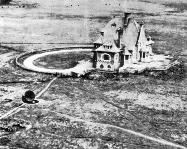
According to the reports, Commander Alfred Rawlinson of the Royal Naval Volunteer Reserve first used the equipment as he needed a means of locating the German Zeppelins during cloudy days. He improvised an apparatus made from a pair of gramophone horns that he mounted on a rotating pole.

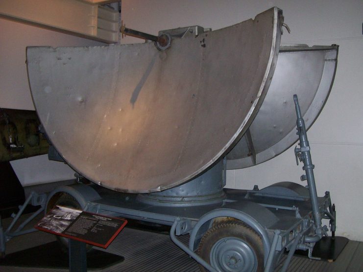
The instruments were usually made of large horns or microphones connected to the operators’ ears through a tube. Imagine a stethoscope but supersize it. From there, an extensive network of sound mirrors that were used from World War I through the Second World War was developed. These sound mirrors worked with a combination of microphones that had to be moved to find the angle that maximizes the amplitude of the sound. Two sound mirrors at different positions were usually set up to generate two different bearings, allowing the operator to use triangulation to point out the direction of the sound source.

The height-locating half of the Czech four-horn acoustic locator
The height-locating half of the Czech four-horn acoustic locator. 

Although the equipment seemed crude by today’s standards, they were able to provide a fairly accurate fix on the approaching planes so guns could be directed at them before they arrived or even when they were out of sight due to low visibility.


                                           Dover Radar Station during WWII

During the half part of World War II, radar became an alternative to these acoustic location techniques and equipment. Both the United Kingdom and Germany knew that they were working on radio navigation and its countermeasures, known as the Battle of the Beams. Their interest in radio-based detection and tracking led to the use of radar. Britain, however, never really admitted that they were using radar and showed publicly that they were using acoustic location.

The Swingate transmitting station is a facility for FM-transmission in the village of Swingate, near Dover, Kent (grid reference TR334429). For many years there were three lattice towers with a height of 111 metres (364 ft). This station was one of the first 5 Chain Home Radar stations completed in 1936 and was originally designated AMES (Air Ministry Experimental Station) 04 Dover. The FM transmitting antennas are attached to what was the middle tower; microwave link dishes and mobile telephone antennas were spread across all three towers. The south tower was dismantled in March 2010, as a result, only two remain. The Swingate towers no longer have the three cantilever platforms that were fitted originally.

  The Sparse construction made it difficult for the Germans to strike the towers and cause any real damage despite the accuracy of their bombers due to the fierce resistance by the RAF and the huge cost that is incurred every time the Germans went after the towers.

In the Battle of Britain, both sides were already using radars and control stations to up their air defense capability. At the same time, the United States, the Soviet Union, and Japan were also developing their own detecting systems. The acronym “RADAR” was not used until 1940, when the US Navy coined the term as an acronym meaning Radio Direction And Ranging. Even after this innovation, the acoustic location stations did not cease operation and acted as a backup to radar. After the war, radar has been so developed that audio aircraft detection equipment was totally obsolete.

At the same time, using sound to accurately detect objects moved from the air to beneath the waves become SONAR, or Sound Navigation And Ranging for submarines and surface vessels to navigate and find targets.


Tuesday, February 16, 2021

The Story of Operation "Biting"

 I recall this raid in my history, my specialty in the Army was ELINT, the British were having a battle with the Germans over Radar. Radar stands for RAdio Detection And Ranging.  The Germans were using Radar beams to guide their bombers over targets in England and the British were working countermeasures, also the Germans were using Radar to identify the British night raids that were trying to attack the German homeland at night so it was turning into a war of technology, the first of its kind.


Parachutes and radar are long-established elements of war. But they both came into their own with Operation Biting. This British raid from the skies took place on the 27th February 1942.

Brave men landed in the northern French commune of Bruneval with the aim of stealing Nazi radar components. They faced incredible odds but came out the other side in triumph.

The Germans had set up a radar installation called “Wurzburg”, which Churchill’s experts wanted to get their hands on. At the time an invisible conflict was going on; “The Battle of the Beams”

As described on the Combined Operations website, the game was to jam your enemy’s kit so they didn’t see you coming. Radar expert Dr Reginald Victor Jones was in charge at the British end.

Lord Mountbatten set the plan for Operation Biting in motion. The lead up to the mission had been perilous in itself. Resistance operatives risked their lives gathering intelligence on Bruneval’s beachside location. Photographs of the target were taken from a Spitfire. This was way before the days of cameraphones, so the pilot really needed to master the art!

Low level oblique of the “Würzburg” radar near Bruneval, France, taken by Sqn Ldr A.E. Hill on 5 December 1941. Photos like this enabled a raiding force to locate, and make off with, the radar’s vital components in February 1942 for analysis in Britain

The recently-formed 1st Parachute Brigade, 2nd Battalion C Company were assigned to the momentous task. They’d been in existence only a matter of weeks. And reaction to their involvement wasn’t exactly positive. As Bruce Crompton explains on his ‘Amazing War Stories’ podcast, “Many in the corridors of power thought the Parachute Forces were a folly, a drain on vital war resources. However Churchill was determined…”

Commanded by Major John Frost, the team were assembled and trained rigorously in (typically co-operative!) British weather. High levels of secrecy were maintained.

As described on the Combined Operations website, the game was to jam your enemy’s kit so they didn’t see you coming. Radar expert Dr Reginald Victor Jones was in charge at the British end.

The men had to fly at night. Yet they remained in the dark over what exactly they were doing. Combined Operations writes, “The parachute unit, for example, believed the War Cabinet wanted them to demonstrate techniques and capabilities for raiding a headquarters building behind enemy lines.”

The Brigade, comprised of 120 men, were traveling by Whitley bomber. They would be dropped 600 ft. The drop was straight through the floor, with a risk they’d receive bumps and bruises before they even left the plane! The men were expected to display ABI, or “Airborne Initiative”, meaning no matter how bad thing got, they did their duty.

Once on the ground they operated in 3 sections. One to take the beach, another to serve as rearguard and reserve. Flight Sgt Charles Cox was part of the third group, who were responsible for raiding the Wurzburg. Offshore was Don Preist of the TRE (Telecommunications Research Establishment), studying Nazi transmissions and collecting data in case Operation Biting didn’t come off.

An early snag was well and truly hit when the beach unit, commanded by Lt Euen Charteris, found themselves 2.5 km out from their destination.

They faced the prospect of running toward Bruneval. The route took them through a village brimming with Germans. Thankfully the night gave them the cover they needed, though one enemy soldier was dispatched after joining them in a jog… the unfortunate soul figured they were Nazis.

Meanwhile, Cox and company were at the radar disc. Hitler’s forces were prepared for the parachutists’ arrival and hot metal flew everywhere. It also became clear the kit couldn’t be pried away with tools. Brute strength was used to dismantle the parts. These were then put on trolleys, with accounts of the loot being ridden down slopes to the escape route.

The Würzburg mobile radar at the Imperial War Museum, London. Image by Ekem CC BY-SA 3.0
The Würzburg mobile radar at the Imperial War Museum, 

Lt Charteris reached the coast and the mainly Scottish team engaged with the enemy in a fight to the finish. Boats were supposed to be waiting for them but these had been forced to hold off while German vessels prowled the waters. Eventually help arrived, and the Brigade were sped away to Portsmouth.

Sadly while casualties were low, 2 men died. One of those was Lt Charteris. The Germans lost 5 men. 6 of the group became prisoners of the Nazis. The Brits captured soldiers of their own and brought them back to extract further information.

The men of C Company on their arrival on Portsmouth, the morning after the raid.

The Parachute Regiment’s ParaData website calls Operation Biting “a small but exciting taste of success at a time when the war was going badly.” It was a victory for Churchill in the media and in the national consciousness. The deadly radar-grabbing mission put Paras on the map and ushered in a new age of technological warfare.