Webster

The Constitution was made to guard the people against the dangers of good intentions." --American Statesman Daniel Webster (1782-1852)


Sunday, January 31, 2021

Where is Witold? His blog is "Gone"

 I was checking my blogroll and noticed that "Behind Enemy Lines" hadn't posted for several days so I clicked on it and got this....


     He ain't on twatter either?, I have a twatter account that I occasionally use and he was on it.  Does anybody have any ideas?

    EDIT:  I got an email from Witold, he pulled his twatter account on account of President Trump being banned and he shut down his blog and saved the information and will open it again under a different name in a bit.

Saturday, January 30, 2021

A warbird crash and the ending report, a "Tante Ju" crashed in 2018

 This came across my email and it caught my eye,, this came from my "Aviation Incident" report that I get to my work email, usually commercial aircraft, but this caught my eye because it was a "Classic" airplane and it reminded me of the "Collins" Foundation and the tragic B17 crash.     This report is from the "Avherald"  I figured my readers would enjoy this story.


Direct cause

The accident is attributable to the fact that after losing control of the aircraft there was insufficient space to regain control, thus the aircraft collided with the terrain.

The investigation identified the following direct causal factors of the accident:

- The flight crew piloted the aircraft in a very high-risk manner by navigating it into a narrow valley at low altitude and with no possibility of an alternative flight path.

- The flight crew chose a dangerously low airspeed as regard to the flight path. Both factors meant that the turbulence which was to be expected in such circumstances was able to lead not only to a short-term stall with loss of control but also to an unrectifiable situation.

Directly contributory factors

The investigation identified the following factors as directly contributing to the accident:

- The flight crew was accustomed to not complying with recognised rules for safe flight operations and taking high risks.

- The aircraft involved in the accident was operated with a centre of gravity position that was beyond the rear limit. This situation facilitated the loss of control.

Systemic cause

The investigation identified the following systemic cause of the accident:

- The requirements for operating the aircraft in commercial air transport operations with regard to the legal basis applicable at the time of the accident were not met.

Systemically contributory factors

The investigation identified the following factors as systemically contributing to the accident:

- Due to the air operator’s inadequate working equipment, it was not possible to calculate the accurate mass and centre of gravity of its Ju 52 aircraft.

- In particular, the air operator’s flight crews who were trained as Air Force pilots seemed to be accustomed to systematically failing to comply with generally recognised aviation rules and to taking high risks when flying Ju 52 aircraft.

- The air operator failed to identify or prevent both the deficits and risks which occurred during operations and the frequent violation of rules by its flight crews.

- Numerous incidents, including several serious incidents, were not reported to the competent bodies and authorities. This meant that they were unable to take measures to improve safety.

- The supervisory authority failed to some extent to identify the numerous operational shortcomings and risks or to take effective, corrective action.

Other risks

The investigation identified the following factors to risk, which had no or no demonstrable effect on the occurrence of the accident, but which should nevertheless be eliminated in order to improve aviation safety:

- The aircraft was in poor technical condition.

- The aircraft was no longer able to achieve the originally demonstrated flight performance.

- The maintenance of the air operator’s aircraft was not organised in a manner that was conducive to the objective.

- The training of flight crews with regard to the specific requirements for flight operations and crew resource management was inadequate.

- The flight crews had not been familiarised with all critical situations regarding the behaviour of the aircraft in the event of a stall.

- The supervisory authority failed to identify numerous technical shortcomings or to take corrective action.

- The expertise of the individuals employed by the air operator, maintenance companies and the supervisory authority was in parts insufficient.

A Ju-Air Junkers JU-52 ("Tante Ju", "Auntie Ju"), registration HB-HOT performing a flight from Locarno to Dubendorf (Switzerland) with 17 passengers and 3 crew, impacted terrain at N46.9001 E9.2288 coming to rest at an elevation of about 2540 meters/8330 feet just southeast of Martinsloch/Piz Segnas (Switzerland) at about 16:50L (14:50Z). A Rescue and Recovery operation has been initiated. All 20 occupants were killed.

Local Police confirmed a Junkers aircraft crashed at Piz Segnas, no further details are known, 5 helicopters have been dispatched for rescue and recovery. Police later added, the wreckage is at an elevation of 2540 meters at the western flank of Piz Segnas. A flight restriction to protect rescue and recovery operation was issued.

In the morning of Aug 5th 2018 local police confirmed HB-HOT of Ju-Air was involved in the accident and announced a press conference at 14:00L (12:00Z).

Ground observers watched the aircraft flying in the area over Obersaxen (Switzerland) south of Piz Segnas and estimated they were flying at 11,000 feet.

Ju-Air confirmed the accident stating on their website: "Accident 4th August 2018: We have the sad duty to announce that one of our Ju-52 aircraft had a accident today. At the moment, no further information is available."

The aircraft had performed a flight from Dubendorf to Locarno on Aug 3rd 2018 and was about to return to Dubendorf.

Mode-S Data show HB-HOT departing and climbing through 4500 feet between 14:20Z and 14:25Z.

A weather station at Crap Masegn (Elevation 2500 meters), about 3.5nm southwest of Martinsloch, reported winds from the north gusting up to 25 knots.

In a press conference on Aug 5th 2018 local police reported all 17 passengers and 3 crew were killed in the accident. Local Police have handed the investigation to the Bundesstaatsanwaltschaft (federal prosecution office). Switzerland's SUST stated that the aircraft did not collide with other aircraft or cables, there is no indication of external influences, the aircraft also did not lose any parts prior to impact. The aircraft came down nearly vertically at high speed, the reason for this scenario needs to be determined. There was no emergency call and no post-impact fire. Ju-Air stated the captain, ex Airforce and Swiss, had 900 hours on type, the first officer, ex Air Force, Swiss and Edelweiss, had 250 hours on type. Ju-Air have suspended their operations, the museum is also closed.

On Aug 6th 2018 a ground witness, a military pilot, reported he had observed the aircraft from his garden about 10 minutes prior to the accident. He saw the aircraft rolling to initiate a left turn when all of the sudden the aircraft tipped over to the left and nose down. One of the motors roared up and seconds later the aircraft was stabilized again and continued its flight normally. The military pilot believes this was a first indication of a serious control problem. It is probable, the witness continued, that they had the problem again up in the mountains and were not able to correct it. If the controls fail in this scenario with the aircraft tipping to the side the nose drops and the aircraft impacts ground near vertical.

On Aug 6th 2018 a ground witness located at the alpine hut at Segnesspass/Martinsloch reported that the aircraft was tracking north passing Martinsloch, but before overflying the ridge the aircraft entered a left turn and then went down, as if following a plumbline. Initiating the turn until impact lasted less than 15 seconds.

On Aug 6th 2018 Switzerland's Civil Aviation Authority (BAZL) announced, that the JU-52 is not being grounded, hence is permitted to fly.

On Aug 6th 2018 the CEO of Ju-Air announced they are planning to resume their flights at around August 17th 2018.

On Aug 7th 2018 BAZL stated that the flight restrictions at Piz Segnas are being ended by the end of day after completion of recovery of the wreckage. BAZL further states that they have taken note of Ju-Air's intention to resume flights on Aug 17th 2018. As long as there is no substantiated suspicion of a technical defect BAZL can not order a grounding of the aircraft. Should new findings be made until Aug 17th 2018, the BAZL will act and if necessary issue a grounding order. Ju-Air have to ascertain that their crews and maintenance personnel are mentally capable to ensure safe flight operations. HB-HOT had been last examined by BAZL on Apr 6th 2018 and received the air worthiness certificate for the next two years after no discrepancies were found.

On Aug 16th 2018 BAZL reported that the investigation so far has not revealed any clues to a technical cause of the crash of Aug 4th 2018. Nonetheless, the BAZL demands that a number of precautionary measures are being implemented by Ju-Air prior to resuming flying operations on Aug 17th: all aircraft must carry a recording GPS receiver to permit assessment of flight routes, the aircraft must observe an increased minimum safety height above legal requirements and the passengers must remain seated with their seat belts fastened throughout the flight and are no longer permitted to move freely within the aircraft (including cockpit visits). Ju-Air have already indicated they are going to comply with the demand. The investigation is ongoing and could take several weeks to months until first preliminary results. Should during the investigation new information of a technical problem be found, the BAZL will again assess the situation and may introduce new measures up to grounding the aircraft.

On Aug 21st 2018 Switzerland's SUST announced they have opened an investigation into the crash. The SUST reported the aircraft entered the enclosed valley southwest of Piz Segnas on a northeasterly heading. Approaching the northern end of the valley the aircraft initiated a left turn which developed into a spiral descending trajectory. A brief time later the aircraft impacted terrain almost vertically. All 17 passengers and 3 crew died in the impact, the aircraft was destroyed, no third parties were harmed, there was minor land damage.

On Nov 20th 2018 Switzerland's BAZL grounded the remaining JU-52 aircraft HB-HOP and HB-HOS of Ju-Air reasoning that the investigation by the SUST brought about substantial structural damage in the area of the wing spars at HB-HOT, which could not be detected during regular maintenance and inspections. According to today's knowledge and investigation findings that damage has no link to the crash of HB-HOT.

On Nov 20th 2018 Switzerland's SUST released a preliminary report in German stating that a number of cracks were found in the area of the left hand engine mount at the lower spar of the left wing as well as corrosion in the area of the wing root. Further examination of the damage is being conducted, at first sight the damage does not appear to be causal for the accident.

A preliminary brief analysis states that there is no evidence the deficiencies found on the wreckage of HB-HOT were causal for the accident. It is likely however, that similiar damage exists on other aircraft of the operator and thus adversely affect flight safety. A number of deficiencies were also found in the documentation of maintenance works as well as in the management of spare parts, which establishes a potential risk.

On Nov 20th 2018 the operator stated that the investigation so far found no technical reasons for the crash of HB-HOT. The SUST detected corrosion at one of the wings of the accident aircraft, however, this damage was not cause of the crash. The summer operation 2018 has already ended, bookings for 2019 are being accepted. The operator agrees with the grounding of their aircraft to ensure that no damage similiar to HB-HOT remains on the remaining aircraft. One of 8 spars is affected at an area that so far was not accesible during regular maintenance and inspections, the damage thus was only detected following the accident. A third JU-52 aircraft, registration HB-HOY and not affected by the grounding because of different production and year, is anticipated to join the fleet shortly.

A NOTAM reports a new rope way cable has been erected at an elevation of 2251 meters/7385 feet MSL about 100 meters/330 feet AGL on Aug 3rd 2018 about 1.3nm south of the crash site, this however was not related (see not related NOTAM below).

On Aug 2nd 2019 Switzerland's SUST released a Status Report reporting that the investigation succeeded in reconstructing the complete flight path of HB-HOT based on photos, videos taken by the passengers as well as by testimonies of witnesses on the ground. The SUST wrote:


It is possible to reconstruct the entire history of the flight based on the various data storage devices, using the following high-precision method for the last minutes of the flight: The valley south-west of Piz Segnas was captured using a three-dimensional laser scan and combined with the three-dimensional terrain model from the Federal Office of Topography. A laser scan of a sister aircraft of HB-HOT was taken and a three-dimensional model of the aeroplane was created. This means that images of the accident aircraft taken from the ground during the flight can now be positioned and analysed with regard to the terrain. This model can also be used to evaluate images from inside the aircraft to determine the flight path. The existing still images and video material should make it possible to determine the positions of the accident aircraft in space, its attitude relative to the terrain and its speed relative to the ground for the critical phase of the accident flight.

At the same time, the audio tracks from the existing video material will be analysed. Spectral analysis of the audio recordings may make it possible to determine the revolutions per minute of the engines and draw conclusions about the condition of the engines during the course of the accident. This work is ongoing, and the STSB is receiving support from the French safety investigation authority, the BEA.

Furthermore, the mass of the aircraft and the position of the centre of gravity are being determined in order to determine their influence on flight performance.

In order to reconstruct the flight characteristics and the aerodynamic parameters prevailing during the course of the accident (e.g. attitude and true airspeed), it is necessary to know the small-scale movements of the air masses in the valley south-west of Piz Segnas. For this purpose, the wind flows in this valley will be simulated using a sophisticated model, with the real wind and temperature data being incorporated as boundary values. In order to validate and quantify the regularity and extent of the effects calculated during this simulation, for several weeks this year, measurements will be conducted in the area of the accident. A traditional weather station will determine the wind, atmospheric pressure, temperature and humidity on the ridge next to the Segnas Pass. A lidar system (Laser Detection and Ranging - a measuring system that emits laser pulses and evaluates the backscattered light from the atmosphere, in this case with regard to the Doppler Effect. In the present case, it is used for threedimensional measurement of wind above the site) will be used to record the three-dimensional flow conditions in the area of the flight path shortly before the beginning of the spiral-shaped flight path. The technical and logistical challenges mean that the success of these measurements cannot be guaranteed. In particular, for the measurements being helpful for explaining the accident of HB-HOT, weather conditions comparable to those on the day of the accident must occur during the midsummer measuring period.


The SUST states in the status report that they estimate the release of the final report for the first quarter of year 2020 if everything continues according to plans.

On Aug 4th 2020 the SUST released their second status report now indicating the draft final report has already been sent out, the investigation expects the final report to be released until end of 2020.

The SUST stated:

The STSB used photogrammetric methods to determine the positions in space of the aircraft involved in the accident, its orientation angles in three axes and its speed relative to the ground, especially for the crucial flight phase before the accident.

An analysis of the audio tracks from the available video recordings made it possible to determine the rotational speed of the engines and to assess their operation during the accident.

In addition to a detailed analysis of the weather conditions, the STSB arranged for the wind flow around the Segnes Pass to be simulated using a fine-mesh model, by means of which the actual wind and temperature data were used as boundary values. Moreover, for several weeks last summer, the STSB took measurements in the area of the accident. In addition to a classic weather station, which measured the wind, air pressure, temperature and humidity on the ridge of the Segnes Pass, a solar-powered wind measuring system (Lidar) recorded the three-dimensional flow conditions in the area of the flight path shortly before the onset of the spiral shaped flight path. This measurement enabled the STSB to reconstruct the wind conditions on the day of the accident in the valley basin southwest of Piz Segnas to such a degree that it could assess their likely effect on the aeroplane involved in the accident.


The SUST also looked into systematic issues like flying tactics in the mountains and general flight operations.

Related NOTAM:
LS W1440/18
B)2018AUG04 1610 C)2018AUG05 2359 EST
E)TEMPO R-AREA ESTABLISHED AT SEGNASPASS RADIUS 9.3 KM
(465408N0091329E RADIUS 5.0 NM). DUE TO RESCUE MISSION, ENTRY
PROHIBITED FOR CIV ACFT EXC HEL EMERG MEDICAL SER (HEMS).
F)GND
G)FL130

Not related NOTAM:
LS B0866/18
B)2018AUG03 0551 C)2018SEP07 2359 EST
E)ROPEWAY CABLE 1.7KM SSE SEGNASP. MARKED, LGTD, LEN 699M, 465238N0091407E, 100.0M / 328.1FT AGL, 2251.0M / 7385.0FT AMSL.


                                              Cracks in the Spars

                                           The Crash from the Ground


                               Crash Scene view from the Helicopters


                                    Map of the Crash site                          


Switzerland's SUST released their final report concluding the probable causes of the crash were:

Direct cause

The accident is attributable to the fact that after losing control of the aircraft there was insufficient space to regain control, thus the aircraft collided with the terrain.

The investigation identified the following direct causal factors of the accident:

- The flight crew piloted the aircraft in a very high-risk manner by navigating it into a narrow valley at low altitude and with no possibility of an alternative flight path.

- The flight crew chose a dangerously low airspeed as regard to the flight path. Both factors meant that the turbulence which was to be expected in such circumstances was able to lead not only to a short-term stall with loss of control but also to an unrectifiable situation.

Directly contributory factors

The investigation identified the following factors as directly contributing to the accident:

- The flight crew was accustomed to not complying with recognised rules for safe flight operations and taking high risks.

- The aircraft involved in the accident was operated with a centre of gravity position that was beyond the rear limit. This situation facilitated the loss of control.

Systemic cause

The investigation identified the following systemic cause of the accident:

- The requirements for operating the aircraft in commercial air transport operations with regard to the legal basis applicable at the time of the accident were not met.

Systemically contributory factors

The investigation identified the following factors as systemically contributing to the accident:

- Due to the air operator’s inadequate working equipment, it was not possible to calculate the accurate mass and centre of gravity of its Ju 52 aircraft.

- In particular, the air operator’s flight crews who were trained as Air Force pilots seemed to be accustomed to systematically failing to comply with generally recognised aviation rules and to taking high risks when flying Ju 52 aircraft.

- The air operator failed to identify or prevent both the deficits and risks which occurred during operations and the frequent violation of rules by its flight crews.

- Numerous incidents, including several serious incidents, were not reported to the competent bodies and authorities. This meant that they were unable to take measures to improve safety.

- The supervisory authority failed to some extent to identify the numerous operational shortcomings and risks or to take effective, corrective action.

Other risks

The investigation identified the following factors to risk, which had no or no demonstrable effect on the occurrence of the accident, but which should nevertheless be eliminated in order to improve aviation safety:

- The aircraft was in poor technical condition.

- The aircraft was no longer able to achieve the originally demonstrated flight performance.

- The maintenance of the air operator’s aircraft was not organised in a manner that was conducive to the objective.

- The training of flight crews with regard to the specific requirements for flight operations and crew resource management was inadequate.

- The flight crews had not been familiarised with all critical situations regarding the behaviour of the aircraft in the event of a stall.

- The supervisory authority failed to identify numerous technical shortcomings or to take corrective action.

- The expertise of the individuals employed by the air operator, maintenance companies and the supervisory authority was in parts insufficient.


The SUST sumarized the sequence of events:

At 16:14 on 4 August 2018, the historic Junkers Ju 52/3m g4e commercial aircraft, registered as HB-HOT and operated by Ju-Air, took off from Locarno Aerodrome (LSZL) for a commercial VFR flight to Dübendorf (LSMD). On this flight, pilot A was sitting in the left-hand seat in the cockpit and piloting the aircraft as the commander, while pilot B was assisting him as the co-pilot sitting on the right.

Following take-off from concrete runway 26R westwards and a 180-degree turn over Lake Maggiore, the flight led into the Blenio valley via Bellinzona and Biasca.

HB-HOT steadily gained altitude in the process. North of Olivone, the aircraft turned into the valley of the Lago di Luzzone reservoir and thus into the Adula/Greina/Medels/Vals countryside preservation quiet zone. This zone was crossed at between 120 and 300 m above ground and at times with a minimal lateral separation from the terrain.

At 16:45, as the aircraft was flying over Alp Nadels, the ISP sent a text message to a friend in Ruschein (municipality of Ilanz) to say that the Ju 52 was approaching the area. The flight subsequently continued eastwards into the Surselva region at approximately 2,500 m AMSL. At 16:51, the aircraft crossed the Vorderrhein valley in the region of Ilanz on a north-easterly heading and initially made a relatively tight left turn, taking it over Ruschein. The flight path then led generally northwards past the Crap Sogn Gion mountain and towards the basin south-west of Piz Segnas. At first, the aircraft approached this basin on the left-hand, western side of the valley.

HB-HOT was climbing at this time, and reached an altitude of 2,833 m AMSL in the Nagens region.

The aircraft made a slight right turn when flying past the Berghaus Nagens lodge (see figure 2). During this phase, at 16:55, one of the pilots informed the passengers of the scenery over the speakers in the cabin and through the passengers’ personal headphones.

To start with, the aircraft was flying at a ground speed of 165 km/h during this phase. By point F2, the ground speed had decreased to 135 km/h, and roughly remained so until shortly before point F3.

Towards point F3, the aircraft’s altitude dropped slightly and the ground speed briefly increased by around 65 km/h to approximately 200 km/h. During this time, its pitch attitude3 was 5 to 7 degrees. Towards the end of this phase, just before point F4, the flight path angle4 changed from -3 degrees to approximately -1 de-gree and the speed of each of the three engines decreased steadily by approximately 20 revolutions per minute (rpm). At point F4, the aircraft was at an altitude of 2,742 m AMSL.

At 16:56:02, shortly after point F4, the speed of each of the three engines in-creased by approximately 40 rpm. At 16:56:09, HB-HOT entered the basin south-west of Piz Segnas at an altitude of 2,755 m AMSL (point F5, see also figure 14) and was therefore approximately 130 m above the elevation of the Segnes pass. The flight crew then navigated the aircraft on a north-north-easterly heading almost in the centre of the valley. HB-HOT climbed slightly during this phase and its flight path angle was approximately 2 degrees; its pitch angle remained at 5 to 7 de-grees. At 16:56:17, the aircraft reached an altitude of 2,767 m AMSL at point F7 and was therefore approximately 140 m above the elevation of the Segnes pass.

HB-HOT flew past the Tschingelhörner mountain peaks and began to reduce in altitude, dropping more than 15 m in approximately 6 seconds. During this phase, the power of the engines was rapidly reduced by 30 to 50 rpm, which meant that the engines were increasingly running at a similar speed5. During this process, the pitch angle increased and the flight path angle continuously became more nega-tive.

When the aircraft was approximately abeam the Martinsloch and at an altitude of approximately 2,766 m AMSL (point F8), the flight crew initiated a right turn during their descent and then made a left turn (point F109, see figure 5). The ground speed was approximately 170 km/h and the difference between the aircraft’s pitch and flight path angles increased to approximately 15 degrees during the right turn. When transitioning into the left turn (between points F9 and F10), the pitch angle was approximately 11 degrees and the flight path angle was around -10 degrees. At this time, the aircraft was flying at approximately 125 m above the elevation of the Segnes pass (see figure 3).

During roughly the next 4 seconds, the aircraft descended by 25 m and the already negative flight path angle became even more negative,During roughly the next 4 seconds, the aircraft descended by 25 m and the already negative flight path angle became even more negative.

After point F13, the roll to the left increased steadily and did not decrease even when a significant aileron deflection to the right was made. The ailerons were then brought into a neutral position and temporarily deflected into a position for a left turn.

At the same time, the pitch attitude began to decrease and the flight path ran in-creasingly steeper downwards whilst the left bank attitude constantly increased (see figure 6).

During this last flight phase, the aircraft experienced low-frequency vibrations. Ul-timately, when the aircraft was 108 m above ground (point F16) its longitudinal axis was pointing downwards by 68 degrees from horizontal. By this time, the elevator had deflected upwards by approximately 13 degrees and the rudder was pointing 2 degrees to the right.

The speeds of the three engines had increased slightly compared to the beginning of the downward spiral trajectory and were between 1,720 and 1,750 rpm shortly before impact.

The roll to the left accelerated significantly during this phase. Shortly after 16:57, the aircraft hit the ground in a vertical flight attitude with an almost vertical flight path and at a speed of approximately 200 km/h.

Reconstructions revealed that, at the time of the accident, HB-HOT’s centre of gravity was at 2.071 m behind the wing’s leading edge. In the images and video footage available that had been captured from inside HB-HOT, there was no evidence of anyone moving within the aircraft or not sitting in their seat between the period when the aeroplane entered the basin south-west of Piz Segnas and up to the beginning of its downward spiral trajectory.


The captain (63, ATPL, 20,714 hours total, 297 hours on type), named Pilot A, was pilot flying, the first officer (62, ATPL, 19,751 hours total, 945 hours on type) named Pilot B was pilot monitoring.

The SUST annotated:

In the last two months prior to the accident flight, pilot A carried out a total of 33 flights on the accident type; 28 of these were with pilot B, who carried out the accident flight with him.

In the months and years prior to the accident flight, various safety-critical flights had been documented on which pilot A had been part of the crew, flying below a safe altitude9 or taking high risks. Between April 2018 and including the day of the accident, at least six flights have been logged which involved flight paths with a risk score of 8 to 10 (see section A1.18.4); on four of these flights, he was working with pilot B. On 6 July 2018, pilot A acting as commander flew, together with pilot B acting as co-pilot, over Munich in the Junkers Ju 52/3m g4e aircraft, registered as HB-HOT, at an altitude considerably below the minimum required level.

During his last line check on 7 April 2018, pilot A flew significantly below the safety altitudes as specified in the Aeronautical Information Publication (AIP) VFR guide. Furthermore, he disregarded essential principles for safe mountain flying. These principles have been published since 1981 and, at the time of the accident, were listed under RAC 6-310 in the AIP VFR guide. The Ju-Air training captain entrusted to carry out pilot A’s line check was, among other things, also a TRI11 and TRE12 for Ju 52 aeroplanes. This training captain rated the per-formance of pilot A as ‘standard’ to ‘high standard’. The choice of flight path was described as “appropriate” and “sensible”.

In the last two months prior to the accident flight, pilot B carried out a total of 41 flights on the accident type; 28 of these were with pilot A, who carried out the accident flight with him.

In the months and years prior to the accident flight, various safety-critical flights had been documented on which pilot B had been part of the crew, flying below a safe altitude or taking high risks. Between April 2018 and including the day of the accident, at least eight flights have been logged which involved flight paths with a risk score of 8 to 10 (see section A1.18.4); on four of these flights, he was working with pilot A.

During his last line check on 12 May 2018, pilot B flew significantly below the safety altitudes as specified in the Aeronautical Information Publication (AIP) VFR guide. Furthermore, he disregarded essential principles for safe mountain flying. These principles have been published since 1981 and, at the time of the accident, were listed under RAC 6-3 in the AIP VFR guide. The Ju-Air training captain who was entrusted to carry out pilot B’s line check and also worked as a ground instructor for the air operator, rated the flight as ‘high standard’. The choice of flight path was described as “considerate” and “anticipatory”.

During a climb in sister aircraft HB-HOP on 6 July 2013, pilot B as commander, together with pilot A in the role of co-pilot at the time, entered the basin south-west of Piz Segnas in a similar manner to during the accident flight and flew over the ridge of the Segnes pass at approximately 30 m above ground.

During this flight, a 180-degree turn or an alternative flight path in the northern section of the basin south-west of Piz Segnas would not have been possible.


The SUST reported that the aircraft had been decommissioned by Swiss Armed Forces in 1981 and was taken over by the association of the friends of Swiss air corps museum, who started commercial flights with it in 1982 and eventually emerged into Ju-Air "responsible for flight operations, aircraft maintenance and the continuing airworthiness management organisation (CAMO)" in 1997. The SUST stated: "When the air operator began using the type Ju 52/3m g4e aircraft for civil aviation, the manufacturer or type certificate holder had long since ceased to exist. At the time of the accident, the Junkers Ju 52/3m g4e aircraft, registered as HB-HOT, had recorded approximately 10,189 operating hours."

The SUST analysed:

Technical factors

The extensive technical examinations have revealed that the Junkers Ju 52/3m g4e aircraft registered as HB-HOT had various technical restrictions. One of these was that none of the three installed BMW 132 A3 nine-cylinder radial engines were still able to reach the rpm specified by the manufacturer. It could also be proven that the aircraft was no longer capable of the flight performance specified in the operating instructions for the aircraft type. Numerous technical defects, such as corrosion damage, were also found during the investigation of HB-HOT. It was also established that various components had been inadequately maintained or replaced by reproduction parts that exhibited qualitative issues. In view of these numerous technical inadequacies, it can be concluded that, prior to the accident flight, the Junkers Ju 52/3m g4e aircraft registered as HB-HOT was not airworthy in either a physical or a formal sense. Nevertheless, the aircraft functioned in such a way that the identified technical defects did not have an effect on the accident. There is no indication that these defects influenced the actions and decisions of the flight crew. This is also proven by the fact that the crew had already flown the aircraft from Dübendorf to Locarno the day before without raising any complaints. Other flight crews did not make any corresponding complaints about HB-HOT in the weeks and months before the accident either. It is therefore possible to con-clude that the flight crews had become accustomed to the limited flight character-istics and were unable to detect the remaining inadequacies. The improper me-chanical condition of HB-HOT and its limited flight performance do, however, con-stitute factors to risk which should be eliminated in future for aircraft of the same type.

Weather

The weather forecasts which the flight crew could consult before the flight showed no signs of unusual or particularly difficult weather conditions. The investigation proved that the weather encountered during the flight was largely in line with the forecasts. Pilot B had already flown from Dübendorf that morning and had experi-enced the weather conditions. Both pilots had already crossed the main ridge of the Alps in a light aircraft immediately before the accident flight. In view of this information and the flight crew’s substantial experience, it can be concluded that the flight crew had sufficient knowledge of the weather conditions prevailing at the time. It must have been clear to the flight crew that it was easily possible to fly around areas affected by local showers or thunderstorms. The weather conditions were suitable for a VFR flight over the Alps and allowed various safe routes from Locarno to Dübendorf to be flown. In view of the forecasts and the actual weather conditions, it can be concluded that it was possible to turn back to Ticino at any time. The weather on the route did not present any surprises and was easy to assess. Furthermore, there is no doubt that the experienced, well-trained pilots were familiar with the phenomenon of a relatively high density altitude at high summer temperatures. Although, as explained above, the aircraft no longer performed as documented by the manufacturer, the temperatures prevailing on that day did not constitute a critical limitation for the planned flight.


The SUST reported: "The OFP prepared for the take-off in Locarno included a mass of 9,737 kg and centre of gravity at 1.98 m behind the wing’s leading edge. The reconstructed value for the mass at take-off from Locarno was 9,387 kg and the centre of gravity at 2.077 m. The rearmost permissible centre of gravity is at 2.060 m behind the reference line."

The SUST analysed the operational factors:

For the accident under investigation, it could be proven that the aircraft was operated with a mass below its maximum take-off limit, both during the outward flight on 3 August 2018 and during the accident flight on 4 August 2018. On both flights, however, the aircraft’s balance was behind the rearmost permissible centre of gravity specified by the manufacturer. It should be noted that if the mass and balance calculations had been performed correctly, using the documentation provided or Ju-Air’s flight planning software, the flight crew would not have been able to identify that the centre of gravity was behind the permitted limit. The reason for this lay in inaccurate raw data and the flawed design of the flight planning software. These shortcomings represent a factor that systemically contributed to the accident.

The SUST analysed the accident flight:

... the aircraft crossed the Surselva region in the municipality of Ilanz on a north-easterly heading and made a relatively tight turn to the left. This manoeuvre took the aircraft over Ruschein (canton of Grisons), where a friend of the flight attendant (ISP) lived. The ISP had sent a text message to this friend using her mobile phone a few minutes earlier, saying that the Ju 52 would shortly be flying over Ruschein. It stands to reason that this noticeable change in heading, which could be seen from the ground, can be attributed to this.

During this phase, HB-HOT was climbing and, at 2,833 m AMSL above the Nagens region, attained the highest altitude recorded on its final flight.

It stands out that, shortly after passing the Berghaus Nagens lodge, the flight crew piloted the aircraft at a speed, which, for a long time, equated to a ground speed of only approximately 140 km/h. Taking into account the headwind during this phase, the aircraft was moving at a true airspeed of approximately 180 km/h. Thus, the airspeed during the approach to the basin south-west of Piz Segnas was approximately 44 % above the stall speed. As turbulence had already occurred during the flight prior this point and it was necessary to initiate a turn in order to cross the pass, associated with a higher stall speed, this safety margin was too small. In addition, even during this phase, the aircraft tended to fly quite low to the ground at just less than 200 m above the elevation of the Segnes pass, which the crew intended to cross. This, combined with the low speed, represented a risky starting point for the continuation of the flight.

This situation did not improve, despite the speed increasing by roughly 50 km/h up to a true airspeed of approximately 230 km/h for a short time, because this increase in speed was not due to an increase in power. Rather, this resulted from a slight descent of roughly 80 m, which reduced the aircraft’s height above ground to ap-proximately 115 m when compared to the Segnes pass. The pass represents the lowest point on the mountain range that borders the basin. Due to the narrowness of the pass, terrain elevations considerably higher than that of the pass must be factored into the choice of flight path in order to safely cross the corresponding ridge.

Upon increasing the speed of all three engines by about 40 rpm, the aircraft rose by approximately 25 m to 2,767 m AMSL, resulting in a height above ground of roughly 140 m when compared to the Segnes pass. At the same time, however, the true airspeed of HB-HOT decreased to 200 km/h and the prevailing headwind steadily eased.

The analysis of the power setting and rpm of the three engines shows that they could be controlled and that the aircraft reacted according to changes in power settings. Neither the maximum permissible engine speed nor the highest possible engine speeds to be expected in view of the proven technical restrictions were achieved. From this it can be concluded that despite the relatively high density altitude and the poor condition of the engines, there was still a reserve of power.

Evaluation of the aileron deflections and the reaction of the aircraft to these control inputs proves that it was possible to control the aircraft and that it reacted accordingly during this phase of the flight.

HB-HOT entered the basin south-west of Piz Segnas and from then on, the pilots navigated the aircraft on a north-north-easterly heading in approximately the mid-dle of the valley. With this choice of flight path, the flight crew may have wanted to give the passengers a good view of the Martinsloch, a well-known geological fea-ture and tourist attraction. Due to the aircraft’s low altitude and the narrow nature of the basin, it was no longer possible to turn back or to choose a flight path other than over the crest of the Segnes pass. It is one of the basic principles of flying in mountainous areas that there must always be the option of an alternative flight path or to turn back. Combined with the aircraft’s low altitude in relation to the pass the pilots intended to cross, the flight crew’s decision to dispense with these safety-related requirements created a very high-risk situation which did not permit any tolerance for further errors, faults or external influences. This type of piloting can be seen as a causal factor of the further course of the accident.
As the reconstruction of the flight path and the wind conditions show, the aircraft began to descend over several seconds while flying past the Tschingelhörner mountain peaks. This was due to downdraughts with a vertical speed of 2 to 5 m/s. Extensive meteorological investigation proved that downdraughts of this kind were present in this area of the basin. They do not represent an abnormal phenomenon in the mountains.

As video footage shows, when the aircraft was approximately level with the Mar-tinsloch, the flight crew initiated a right turn during this descent and then made a left turn. The true airspeed was approximately 180 km/h and the difference be-tween the aircraft’s pitch and flight path angles increased to approximately 15 de-grees during the right turn.

During this phase, the power of the engines was slightly reduced, although the characteristics of the manner of control input suggests that the flight crew was in the process of synchronising the three engines. At the same time, the aircraft’s pitch attitude increased further and the descending flight path became increasingly steeper.
It is conceivable that due to their preoccupation with the engines and the view from the cockpit, which made it difficult to easily recognise the descent, the flight crew’s increase in pitch attitude was made subconsciously in order to compensate for this (see figure 21). Furthermore, the fact that the centre of gravity was beyond the rear limit facilitated the process and made the aircraft more unstable around its pitch axis, which represents a factor that directly contributed to the accident.

The aeroplane then assumed a rate of descent of approximately 6 m/s that subsequently increased further, which, based on the analysis of the flight attitude, speed and airflow conditions in the basin south-west of Piz Segnas, can no longer be attributed to a downdraught. Due to the high pitch attitude and the clearly downward flight path, it is also impossible that this descent was caused by the flight crew using the elevator control. Rather, it can be concluded that the aircraft was in a situation in which the airflow at the wing had at least partially stalled. It should be noted that a stall can occur regardless of the aircraft’s speed if the critical angle of attack for the wing profile is exceeded.

From an aerodynamic point of view, the stall can be explained as follows: HB-HOT had been caused to enter a descent by an area of downdraught. The descent in the downdraught, which was partially compensated by increasing the pitch attitude, led to a flight attitude close to the maximum angle of attack. Given this flight attitude, the additional increase in the angle of attack caused when flying into an up-draught was sufficient to lead the airflow to at least partially stall. This development would not have been expected had the downdraught continued or eased slowly. The air currents observed in the basin indicate that the aircraft was moving from an area of downdraught into an area of updraught. A change in the vertical com-ponent of the wind’s vector from a downdraught with a speed of 2 to 5 m/s to an updraught with a speed of 0 to 3 m/s was sufficient to exceed the critical angle of attack (see figures 22 and 23). As both the measurements and the airflow calcula-tion have shown, even larger shear values were easily possible. Correspondingly turbulent conditions in the mountains are not unusual and become a risk when flying close to the terrain.

It is therefore also one of the fundamental principles of flying in mountainous areas that the airspeed, and thus the energy of the aircraft, must be increased during turbulent conditions and when in closer proximity to the terrain, so that wind shear does not cause a stall, even if it would usually only do so for a short time. It must be ensured that the aircraft is not overloaded by gusts or deflection of the control surfaces, so that the calculated manoeuvring speed lends itself to be the optimum speed. HB-HOT had a true airspeed of approximately 180 km/h during this phase (when it encountered wind shear) which was roughly 55 km/h or 44 % above the stall speed in the prevailing conditions. This level of speed reserve is too small for the turbulence that is common in the mountains.
As has been proven, the flight crew did not use the engines’ available power re-serves to consistently achieve an airspeed within the design manoeuvre speed range, which under the prevailing conditions was a true airspeed of 197 km/h. If the design manoeuvring speed cannot be achieved during horizontal flight, which is possible for aircraft with a relatively large mass-to-power ratio, this speed must be aimed for when descending. This in turn requires a sufficiently large altitude reserve to be created in advance. In any case, when flying in the mountains, great attention must be paid to ensuring a safe energy level for the aircraft.

In this investigated accident, the flight crew did not follow this important principle. This is shown, inter alia, by the fact that, at a time when the aircraft was already flying too low and too slowly in the basin, they further reduced the power of the three engines. The choice of a dangerously low airspeed with regard to the flight path is therefore a further causal factor of this accident.

Video footage further shows that during this situation, which resembled a deep stall, the angle of bank to the left increased steadily. Once the bank angle reached approximately 30 degrees, there was initially a small and then a significant correc-tive deflection of the left aileron downwards, which was intended to achieve a roll to the right, or rather to counter the roll. From this, it can be concluded that the flight crew intended to stabilise the left turn at a constant bank angle and had prob-ably not really noticed the stall yet. At this time the aircraft was at an altitude of approximately 2,725 m AMSL and was therefore still at a height above ground of roughly 100 m compared to the Segnes pass.

However, the roll to the left did not slow down and the bank angle continued to increase. The ailerons were then brought into the neutral position and slightly de-flected into a position for a left turn. At the same time the nose of the aircraft began to drop. This sequence of events can be explained as follows:

- During this phase the aircraft was proven to be in a situation that could no longer be controlled or in which it was impossible to prevent the roll motion to the left, at least momentarily.

- The uncontrolled rolling motion of the aircraft occurred because the airflow was stalling on the left wing (on the inside of the turn), at least to a greater extent than it was on the right wing. This resulted in an asymmetrical distribu-tion of lift. The turbulence may also have generally had an asymmetrical effect. In the process, the right wing produced more lift than the left wing and allowed the aircraft to roll further to the left.

- Ju-Air’s Junkers type Ju 52/3m g4e aircraft were known to roll towards the in-side of the turn in the event of a stall during a turn, which leads the bank angle of the aircraft to further increase and subsequently decrease both the pitch attitude as well as the turn radius.

- The angle of attack must be reduced in order to stop the stall and bring the aircraft back under control. The way to achieve this is to reduce the deflection of the elevators and adjust the ailerons in the direction of the roll. Under no circumstances should an attempt be made to stop the roll by adjusting the ailerons in the opposite direction of the roll, as deflecting the aileron on the wing that is on the inside of the turn downwards only increases its angle of attack, making it more difficult for the airflow to reattach to the wing.

- In this investigated accident, the experienced pilots reacted appropriately and evidently tried to bring the aircraft back under control by adjusting the ailerons in the direction of the roll.

In principle, this initiated the process of bringing the aircraft back under control. It was, however, no longer possible to successfully perform this manoeuvre due to the aircraft’s proximity to the terrain, as a corresponding simulation has shown.

The sequence of events in the lead up to the aircraft’s collision with the ground in terms of flight mechanics can be explained as follows: As video footage recorded from inside HB-HOT shows, the aircraft was subject to low-frequency buffeting dur-ing its increasingly steeper flight path, which indicates that the airflow was stalling once again on the wing or horizontal stabiliser. The last photograph of the aircraft before impact shows that the wings were deflected upwards to a lesser degree than when in horizontal straight flight and that the elevators had been deflected upwards to approximately half of their full deflection. The rudder was deflected slightly to the right. At this time the aircraft was approximately 108 m above the ground. A little over two seconds later, it rolled a further 186 degrees to the left and hit the ground in a vertical flight attitude with an almost vertical flight path at a speed of approximately 200 km/h. These values also indicate that during the attempt to regain control at an airspeed of between 170 and 200 km/h, the critical angle of attack was exceeded again due to an accelerated stall. It also becomes clear that at the time when the last photograph of HB-HOT was taken, there was a pro-nounced uneven distribution of lift, which led to a roll rate of approximately 90 de-grees per second in the final phase of the flight.

Both the analysis of the engine noise and the forensic examination of the throttle levers show that the full-throttle limiter was set to ‘on’ during the last phase of the flight. This means that the flight crew had not brought the engines up to the highest possible power.


The SUST analysed the human factors:

The following examines the reasons as to why two very experienced, well-trained pilots flew the aircraft into the basin south-west of Piz Segnas in such a risky man-ner, thereby creating the conditions that enabled the accident to happen.

The investigation proved beyond doubt that both pilots were aware of the basic principles of flying in mountainous areas as described above. It is therefore impos-sible for this situation to have occurred due to ignorance. The investigation also ruled out the possibility that an incorrect altimeter reading could have deceived the pilots with regard to the true altitude of the aircraft upon entering the basin. Video recordings of the altimeter displays during the accident flight prove that the altime-ters were set to a suitable reference barometric pressure. By comparing these readings with the actual altitude flown, determined using radar data and photo-grammetric measurements, it can be concluded that the altimeters gave accurate readings based on this reference barometric pressure and that the actual altitude was, in fact, greater than that indicated by the altimeters due to the temperature change in the atmosphere. From the data available it can also be concluded that, when entering the basin at an actual altitude of 2,750 m AMSL, the crew was shown an altitude of approximately 2,650 m AMSL on the flight deck. As former Swiss Air Force pilots, the two pilots would have had extensive geographical knowledge and known the elevations of all major alpine passes, as these are taught intensively during the training to become military pilots. It can therefore be assumed that, even without using a map, the flight crew knew that the Segnes pass, which lay ahead of them, had an elevation of 2,625 m AMSL. This in turn suggests that the entry into the basin was the result of a conscious decision. It is, however, also conceivable that the crew did not pay attention to the altimeters and instead entered the basin purely on the basis of visual impressions, as is often the case when flying in mountainous areas.

This risky behaviour was ultimately the result of the pilots’ flight training coupled with their development in Ju-Air’s operational culture, which led them to become accustomed to this kind of flying. In the months and years prior to the accident flight, several safety-critical flights were documented in which pilots A and B, either individually or in some cases together, failed to comply with safety-related regulations ...

In summary, it should be noted that under the conditions prevailing on the day of the accident, it was easily possible to fly through the basin south-west of Piz Se-gnas at the appropriate altitude and reach the northern side of the Alps by crossing the Segnes pass. In addition to all of the investigations which have led to this con-clusion, this is also illustrated by the fact that around one minute prior to the acci-dent involving HB-HOT, a trainee pilot and their flight instructor on board a motor-powered Cessna C152 aeroplane were able to fly over the ridge of the Segnes pass from south to north. The crew had chosen a flight path that would have al-lowed for a 180-degree turn or an alternative flight path at any time. However, this aircraft was also piloted at an altitude above the ridge which did not comply with the rules for safe mountain flying as published in the Swiss Aeronautical Infor-mation Publication (AIP). The flight crew of the Junkers Ju 52/3m g4e involved in the accident was demonstrably accustomed to breaking the commonly accepted rules for safe flying and taking high risks, which led to the flying tactics described. This habit therefore constitutes a factor which directly contributed to the accident.


Explanatory video by SUST (Video: SUST):
https://www.youtube.com/watch?v=jGF4ovuSrK0


                      Flight Trajectory

Still Image abeam Martinloch

Reconstructed Flight Path


Thursday, January 28, 2021

What To Do If You Are Being Followed.

 I have been really busy at work.   This article goes along with the Situational Awareness post that I have posted in the past,    I shamelessly clipped this from "Art of Manliness", I have used several of the suggestions in the past when I suspected someone was following me.  Usually at night I will get some yahoo will follow me for whatever reason and I will not go home, and go in different directions and head farther away from my house.  I had my son one time call me scared out of his mind because some guy in a truck with high beams on was tailgating him home from work, I told him to head home and I will be waiting with a shotgun, and I was.  But luckily the guy broke off before he got to my sub division.  Normally I wouldn't have done that, I haven't had a chance to discuss with him what to do if someone was to get "cute " with him on the way home.  After that incident, I had a long discussion what to do including call the PoPo and get them involved and other things.  He wants to keep a shotgun in his truck, but as a student, that is problematic at best for the moment until he graduates from High School.    

Man being followed on the street illustration.


You arrive at your favorite coffee shop in the ‘burbs and notice a guy in a green baseball cap standing behind you. You give him a friendly nod and go back to looking at the menu.

While you’re taking a bite from your Arby’s roast beef sandwich during your lunch break downtown, you notice that same guy in the green ball cap at a table outside. “Huh. Small world. What a coincidence,” you think to yourself.

Work is over, and you roll up to the gym to get your sweat on. While you’re walking to the entrance, you glance over and see Mr. Green Baseball Hat sitting in a car in the parking lot.

You get the sinking feeling that this third spotting isn’t a coincidence and that maybe this guy is following you.

What do you do?

Why Would Someone Follow You?

Unless you’re a criminal or suspect in some crime, you probably think you don’t have to worry about being followed.

But even if you’re a law-abiding citizen, there’s a chance you could be followed at some point in your life by people who’d like to do you harm: an angry employee that you had to fire; a crazy ex; friends and family of said crazy ex; an unstable person you unintentionally offended at church; a weirdo you met once at a party who is now obsessed with you; the guy you accidentally cut off in traffic three miles back; a thief who’s decided you’re a good mark. The list goes on.

There’s also a chance you might be followed by a private investigator due to a divorce, custody battle, or other litigation you’re involved in. If that’s the case, you want to provide as little information to the PI as possible to avoid inadvertently giving your legal opponent fodder that somehow helps their case.

The chances of these kinds of people following you are slim. But if you do find yourself in this situation, it’s good to have a plan on what to do.

An Ounce of Prevention Is Worth a Pound of Cure: How to Be Less Followable

If you don’t want someone following you, the best thing to do is to make yourself less “followable” in the first place. Stalkers, PIs, or people who want to do you harm count on the fact that you have a set routine that they can easily follow along with. You subtract that advantage, and make yourself less of an easy target, by making your schedule less predictable. If you can, mix up how you get to work throughout the week. Don’t go to the same places on the same days and at the same times.

Also, don’t broadcast your whereabouts on social media. Turn off location services that indicate where you’re posting from. Would-be stalkers will check this info so they can pinpoint your movements.

How Do You Know If Someone is Following You?

You’d be surprised how easy it is to tail someone without them knowing, as most people aren’t paying attention to their surroundings. So the first step to figuring out if you’re being followed is to start keying in on what’s going on around you. Maintain situational awareness while you’re out and about and establish baselines. What’s normal for the situation or environment you’re in?

Once you’ve established baselines, pay attention to possible anomalies. Is someone looking at you more than is normal and making an unusual amount of eye contact? Does a car you don’t recognize keep driving by your house? Has someone been showing up to your favorite coffee shop who doesn’t fit the typical crowd? These are anomalies and should put you on the alert that someone might be following you.

One anomaly to register is seeing the same person, in three different places. Ex-CIA officer Jason Hanson gives this rule of thumb used in the intelligence community:

One time=an accident

Two times=a coincidence

Three times=enemy action

In addition to noting anomalies, pay attention to your gut feelings. You’ll often intuitively know when something is wrong.

Then, if you experience those uncomfortable feelings, try to confirm them. How you do so will differ as to whether you’re in a car or on foot.

In a Car

If you suspect someone is tailing you in a car, you can confirm it by doing the following:

Tell about road map illustration.

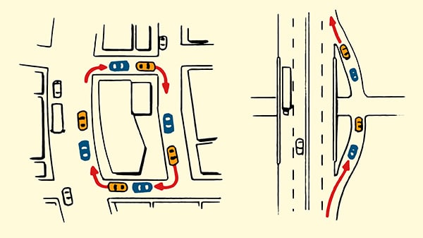
1. If you’re on city streets, make four right turns. If the car is still behind you after the fourth turn, they’re probably following you. Most people don’t travel in circles around city blocks.

2. If you’re on the freeway, get off and then immediately get back on. If you can still see the car in your review mirror, you’re probably being followed. Just as most people don’t travel in circles on city streets, most people don’t get off and then right back on a freeway.

You can also get over to the right lane of the highway, and slow down to 15 miles or so below the speed limit. All the cars behind you will soon pass by. If the one you’ve had your eye on doesn’t, it’s almost assuredly following you.

On Foot

Routines followed illustration.
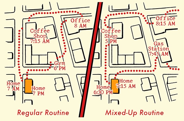
1. Mix up your routine.
 If you’ve got a daily routine, you likely see the same people at the same time at the same places. For example, if you go to the gym every day at 6 PM, you’re probably going to see the same people there. Thus, it’s hard to tell if someone you always see some place is following you, or just has a similar routine to yours.

So if you suspect someone has been following you, you can further confirm it by mixing up your routine. Instead of going to the coffee shop at 7 AM like you usually do, go to a convenience store. If you see your potential pursuant at the convenience store too, there’s a good chance they’re following you. You can increase your certainty of being followed by going to different places at different times. If you see the same person no matter the time and no matter the place, you can be pretty sure they’re following you.

2. Mix up your walking pace. If someone is tracking you, he’ll likely match your walking pace. If you speed up, he’ll speed up. If you slow down, he’ll slow down. If you pause, he’ll pause. So mix up your pace and observe how your suspected stalker responds. If he matches your pace, there’s a good chance he’s following you.

3. Pause and turn. Hanson suggests this effective tactic for determining if someone is following you:

While you are walking, simply pause, turn around, and pretend to do something — like check your phone, tie a shoe, or turn around as if you were looking for someone. Then look directly at the person you think is following you. Your typical amateur who is following you is going to get flustered and give herself away. She’s likely to freeze or act unnatural because you have caught her by surprise. In other words, someone who is following you will not exhibit the same natural behavior as someone who is simply walking down the street.

4. Change direction. As you’re walking, stop and turn around 180 degrees and start walking towards the person you suspect is following you (only do this in a public and crowded space). If your suspected stalker also flips around and starts walking behind you again, you can confirm that you’re being tailed.

What to Do If Someone Is Following You

So you’ve confirmed that you’re being followed. Now what? If possible, you want to avoid a confrontation, which all self-defense experts agree is better than needlessly getting into a violent encounter.

To do this, follow these two general rules, as well as guidelines that pertain specifically to whether you’re driving or on foot.

Rule #1: Don’t go home. Whether you’re walking or driving, don’t go to your house. It’s natural to want to get home and lock the doors, but if your tail doesn’t know where you live, you don’t want to reveal that information by taking him there.

Rule #2: Stay in public, well-lit, and well-populated areas. Don’t go anywhere that will put you by yourself with your pursuant. If you’re in your car, stay on main roads that are well-lit and don’t go down country roads or secluded streets. If you’re on foot, stay in public areas where there are lots of people. You don’t want to go down isolated alleyways where you can be cornered. If someone seems to be following you in a store, you also don’t want to go out to your car; the stalker could ambush you in the parking lot or follow you home.

In a Car

Gather info. If you’ve confirmed you’re being followed in your car, start getting information on the tailing vehicle to potentially look into yourself or pass along to the police. Get the vehicle’s make and model. And if you can score the license plate number, even better.

Call the police. If you feel threatened, call the police to let them know what’s going on. Or simply drive to your local police precinct, and tell them you believe you’re being followed. Give an officer the information on the car that’s following you and let them take it from there.

Evasive driving illustration.

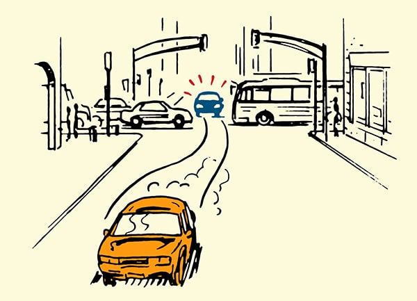
Use well-trafficked roads with lots of stoplights and stop signs. Your pursuant might get stuck at a light or behind more traffic, giving you the chance to shake him off.

Be ready for evasive maneuvering. While on the roads and at stoplights, maintain enough distance between you and the car in front of you that you can make an escape maneuver if needed. If you can see the tires of the car in front of you, you’re good.

Only return home once you feel sure you’re no longer being followed by your tail.

On Foot

Call the police. If you believe you’re being followed on foot by someone with ill intentions, call the police and give them a description of your pursuant. Keep the police on the phone for as long as possible. If your pursuant is nearby, talk loudly so he or she can hear what you’re saying. If there’s a police precinct nearby, go to it.

Man escaping being followed onto subway illustration.

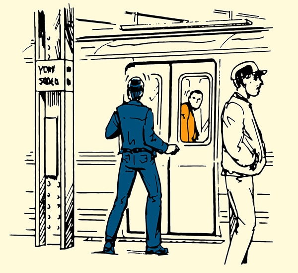
Use public transportation to shake your tail. If you know the public transportation departure times, you can hop on a bus or subway at the very last minute to lose whoever’s following you.

Acknowledge your follower. One tactic Hanson recommends using in public areas is to simply let your follower know that you know they’re following you. Turn around and look right at them. If you’re feeling brave, ask “Can I help you?” Or “What do you want?”

Most bad guys are criminals of opportunity. They’ll only go after you if they think you’re a “soft target” — that they have some sort of tactical advantage over you. Following you without you knowing is one such advantage. By acknowledging their presence, you take it away. Once they realize you’re alert to their tail and they’ve been spotted, they’ll often get flustered and immediately disengage. You’d be surprised how often a show of assertiveness will cause a would-be criminal to back down (at least if their behavior is of the social aggression rather than asocial type; if the latter, you should be prepared to fight back).

Again, you generally only want to use this tactic if you’re in a well-lit and well-populated area, in case the stalker advances instead of retreats. You want witnesses.

But What If I’m On the Lam, Jason Bourne Style?

If for some reason you find yourself in an international, high-stakes espionage manhunt like Jason Bourne, the tactics above aren’t going to work. In fact, you’re pretty much hosed. First, it’s going to be very difficult to even determine that you’re being followed. Highly skilled, professional trackers will use teams of people to co-ordinate surveillance on you. Instead of a single person following you everywhere you go, they’ll throw you off by having one person follow you in one area and another person follow you when you arrive somewhere else. They can even swap those people out to avoid you getting suspicious.

Even if you do figure out you’re being followed, because professional investigators work as a team, it’s hard to shake them. You might be able to delay their finding you, but they’ll almost assuredly get you in the end.

Long story short: try not to get into a Jason Bourne-style manhunt.

But if you’re being pursued by a more garden-variety stalker, the tips above will help.